Home

To Our Loyal Readers – We’re Back

Leave a comment

NOTE TO READERS: In keeping with our philosophy of lifelong learning, we are now on Twitter as @cachemaniacs. If you’re interested, there’s a Twitter follow button over on the sidebar or you can just click the link above.

I’m back from my self-imposed 92 day exile.  We spent the winter in Tucson, Arizona, which is going to be Snowbird Central from now on. We saw and did a lot of great stuff and I’ve got a lot in the writing queue. To be honest, I just ran out of gas and put the writing aside.  It was time for a break.

The San Francisco Peaks 

Arizona has many faces, which is one of the reasons we go there. Mountains, desert, alpine forests, even the ocean if you’re willing to go 50 miles into Mexico from Yuma. These are the San Francisco Peaks north of Flagstaff. The highest peak has an elevation of 12,600 feet and you can walk right up to it weather permitting. There’s also a big ski resort up there – Snow Bowl. All the peaks used to be one giant peak that reached up to 16,000 feet. It was blown apart in a volcanic eruption thousands of years ago. This area north of Flagstaff in the NE corner of Arizona is an active volcanic region called the San Francisco Volcano Field. Although quiet now, it is still active. The last major eruption was about 800 years ago. It formed the huge cinder cone which is now Sunset Crater National Monument. This photo was taken at the park entrance.

But I think the writing mojo is back, especially with the all the Civil War stuff going on this year. I like to write about smaller and/or lesser known battles on their anniversaries or present some new background on others. I wrote about the Alamo and the Doolittle Raid earlier this year. I missed the Little Bighorn and Gettysburg. Missed one yesterday too – the Union Civil War attack on Battery Wagner by the 54th Massachusetts. This was the first black regiment in the Union Army. The attack was the climactic scene in the movie “Glory”. 

Desert Winter

Yes, it snows in the desert and when it does, it’s beautiful – although Arizona drivers can be hazardous. This photo was taken in Catalina State Park in Oro Valley, AZ after an overnight snowstorm of wet, heavy snow. The snowline got down to under 2,500 feet, which is the altitude here. The snow on the low ground was gone shortly after sunup but in the mountains, it lasted for several days. The peaks in the back are the Santa Catalinas. They reach up to about 6,000 feet here and eventually climb to over 9,000 feet at Mt. Lemmon, which has a ski resort overlooking Tucson. Catalina Park has one of the largest concentrations of saguaro (swor’oh) cactus in the world. The 50 square mile park has over 5,000 of them.

So welcome back and enjoy what’s coming down the pipeline.

Cheers … Boris and Natasha

Casa Grande Ruins National Monument

Leave a comment

NOTE TO READERS: In keeping with our philosophy of lifelong learning, we are now on Twitter as @cachemaniacs. If you’re interested, there’s a Twitter follow button over on the sidebar or you can just click this link.

Shortly after the birth of Christ, an indigenous race started to inhabit the Sonoran desert in southern Arizona halfway between present-day Phoenix and Tucson. Nobody really knows who they were, where they came from or what happened to them. History calls them the Hohokam. Anthropologists prefer a more generic term – ancient Sonoran desert people. Starting out as hunters and gatherers, they quickly advanced beyond that. Over the course of the next 10+ centuries, on the banks of the Gila River, they developed a thriving culture with sophisticated knowledge of agriculture, architecture and astronomy. They achieved all this despite having no tools, no working animals and no livestock. They never knew about the wheel and they had no written language. Then, in the space of one or two generations, they were gone. We know all this because of what they left behind at the Casa Grande Ruins National Monument.

Casa Grande National Monument

The high point of this ancient Sonoran culture was the construction of a large central building, which Spanish missionaries named “Casa Grande” over 250 years after it was abandoned. Sixty feet square and four stories high, nobody really knows what it was used for. It was built with a substance called “caliche” (cuh-LEE-chee). Hard clay under the desert floor was ground up and mixed with water to create a sticky mud that could be molded like Play-Doh and dried as hard as rock. This was the main construction material used for everything. Casa Grande contained an estimated 3,000 tons of caliche, all hand molded in two foot layers built on top of one another without scaffolding or tools. Floors and internal supports were built with pine and fir logs brought from 50 miles away and imbedded in the wet caliche. Fifty years after its completion around 1350, the Sonoran culture fell apart. For four centuries after it was abandoned, Casa Grande stood mute, ravaged by weather, vandals and souvenir hunters. You can still see graffitti carved into the walls by stagecoach passengers and cowboys. The U.S. Government began preservation efforts in 1891. It became a National Monument in 1918. The protective roof was built in 1932. Preservation efforts are ongoing and have successfully maintained the ruins in their 1891 state.

The achievements of this long gone culture were astounding. The Casa Grande is an obvious one but there were many more. Using only pointed sticks, they dug hundreds of miles of irrigation canals to bring water from the Gila River into the desert. This created an oasis of almost 1,000 square miles of fertile crop land in which they grew corn, beans, squash, tobacco and cotton. Artisans created pots, jewelry and baskets with intricate artwork, some of which have been found in the area. Trade flourished down into Mexico and all the way to the Pacific coast. But, in my humble opinion, the most fascinating part of the culture was their interest in astronomy. The walls of the Casa Grande have tales to tell about that.

The Sonoran culture tracked major astronomical events to guide their planning, activities and religious ceremonies. Key among them were summer/winter solstice and the spring/fall equinox. They did this through a series of “alignments”, which were holes or channels constructed in the Casa Grande walls. On the day of those celestial events sunlight would shine directly through those alignments. There was one other event they tracked – the 18.6 year lunar nodal period. This is a cycle of declination (angle) changes of the moon’s orbit around the earth. Throughout ancient history, it was used for ceremonial religious observances, particularly among pagan religions. However, the lunar nodal cycle is also a key component of eclipse prediction. This cycle is followed at many ancient sites, including Stonehenge. Could the ancient Sonoran desert people predict solar and lunar eclipses? Your guess is as good as anybody’s.

West wall of Casa Grande

This picture is the west wall of Casa Grande. It is the best preserved and the most interesting. The round portal under the gold arrow was the alignment for the summer solstice – the longest day of the year. The square portal under the blue arrow was the alignment for the peak of the lunar nodal period, which astronmers call the lunar standstill. Other alignments are have been identified but are not readily visible and some are just gone, eroded away with the walls.

Casa Grande was completed around 1350. By 1400, the Sonoran culture was in a steep decline from which it couldn’t recover. Theories abound as to why. There’s no evidence of warfare or conquest. The conquistadors were still two centuries away. One version that seems credible is supported by geological data. In the late 1300’s, the Gila River Valley experienced flooding on a monumental scale. This deepened the river channel to the point where no water could flow into the irrigation canals unless they were rebuilt. This flooding was followed by years of drought, which lowered the water level even more. The desert began to reclaim its land. Unable to sustain themselves, the Sonoran people began to leave. Within 30-40 years, this 1,000 year culture was gone. They most likely dispersed to different areas in smaller groups and formed the genealogical base of today’s southwest tribes.

Sonoran canal system

This National Park Service diagram shows the extent of the Sonoran irrigation system. There were hundreds of miles of canals. Parts of it are still in use today. This entire system was dug with pointed sticks, the most sophisticated tool they ever developed.

At its peak, the Sonoran culture had several thousand people living in compounds over hundreds of square miles on both sides of the Gila River. The Casa Grande was one of these compounds, centered on a one acre site surrounded by seven foot walls. It was just one compound out of many, although it was the biggest. This culture pre-dated other Native American cultures and lived in peace. Today, the Pima, Hopi and Zuni nations consider this culture to be their ancestors

Excavated canal.

In this 1964 photo, an archaeologist is standing in an excavated section of a Sonoran culture irrigation canal. They were built with steps for gravity flow and lined with caliche. Not bad for pointed sticks.

Casa Grande Ruins National Monument is located in Coolidge, AZ – about 20 miles due north from Exit 211 on I-10. It’s small. You can see the entire thing in 60-90 minutes. Nevertheless, it is one jaw dropping discovery after another. If you get out to Arizona, make sure you take the time to visit.

Cheers … Boris and Natasha

Top 10 geocaches – #5

4 Comments

Hi again,

We continue to count down our Top 10.  Here’s what we have so far.

#10 – Easy to Overlook Cache, Tucson, AZ

#9 –  Nuke on a Mountain Cache, Sundance, WY

#8 – The Caves of the Door Bluff Headlands Cache,  Door County, WI

#7 – Spooky Tunnel Cache,  Kuhntown, PA

#6 – Trolls Cache, Livingston, MT

Google map of the geocache.

Shown is the location of the Dragoon Springs geocache. Don’t let the close proximity of I-10 fool you. This is rugged desert back country with no cell phone service and no AAA.

Trying to nail down the Top 10 is sometimes elusive because as we travel around, we run into a lot of potential Top 10’s.    Basically, to make the list, there has to be something extraordinary about the geocache under consideration.  It might distance, difficulty, uniqueness, history or just the surroundings.  Our #5 cache fell into all of these.  From January 2012, welcome to the geocache at Dragoon Springs.

In the high desert Chiricahua and Dragoon Mountains of southeast Arizona, a number of natural springs gurgle out from amongst the rocks.  One of them was Dragoon Springs.  This area was the homeland of the Apache, who didn’t take kindly to trespassers.  Since water was critical, they watched and guarded the springs aggressively against interlopers from the Conquistadors to Mexican bandits.

Station at Dragoon Springs

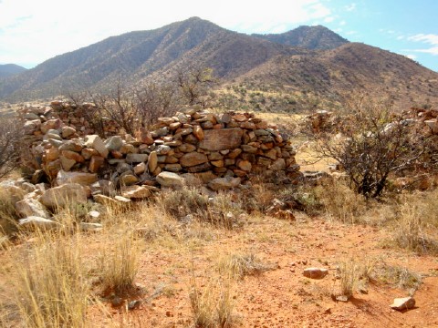
Ruins of the stage station at Dragoon Springs. This was a “swing” station which had only horses and water. “Home” stations had food, quarters and maintenance. The livestock and the workers all lived inside the big stone corral, which was 10 feet high and up to four feet wide. There was no roof. This gave protection from Indians, bandits and predators which abounded, including mountain lions, bears and wolves.

The Gadsen Purchase of 1853 made the land part of the United States.  White settlers, ranchers and miners began arriving in great numbers and a large military presence was also established.  In the decade before the Civil War, the whites and the Apache, under Cochise and Mangas, observed an uneasy truce.  In 1857, the Butterfield Overland Stageline began operation through the area on its way from St. Louis to San Francisco.  They had way stations with food and fresh horses at each of the springs.  One of them was Dragoon Springs.   In 1861,  the Apache ended the truce and started ridding their lands of whites.  The Butterfield stages became prime targets, with 22 drivers killed in 16 months.  The line was already in financial trouble.  Apache attacks and competition from the Pony Express finished the job.  It folded just after the Civil War began.

Dragoon Springs

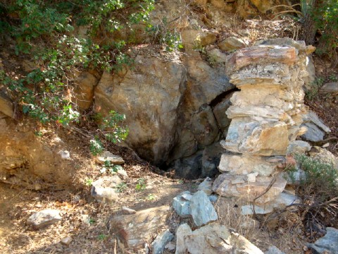
The site of the actual springs, which no longer run. They were sealed off by an earthquake in 1880. The wall was built by ranchers after the Civil War to keep cattle out. Water flowed down the wash and was channeled into tanks to water livestock. The geocache is about a quarter of a mile uphill off the top of the picture.

The way stations and the route itself were the only transportation and logistics infrastructure in the entire region, so they were used by both sides in the desert war of 1862.  In this little known theater of the Civil War, the Union Army, the Confederate Army and the Apache all fought each other.  The abandoned Butterfield Stage station at Dragoon Springs was the site of two fights between Confederate cavalry and Apache war parties.

On May 5, 1862, a Confederate patrol was foraging and rounding up stray cattle in the area around Dragoon Springs.  They were jumped by an estimated 100 Apache at the now abandoned stage station.  Four Confederate soldiers were killed and the livestock stolen.  The rest of the patrol got away. This was the First Battle of Dragoon Springs and they were the western-most combat deaths suffered by the Confederacy.

Dragoon Springs National Historic Site

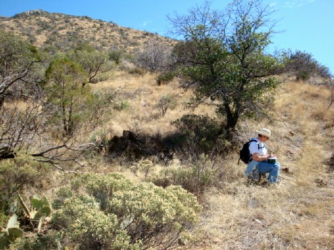
Dragoon Springs Station is now a National Historic Site. Getting to it requires either a long hike or four wheeling over some of the worst terrain I’ve ever had to negotiate. It took us several hours. The site and the scenery are worth the trip. This is an overview of the whole site with a cameo appearance by Team Snowbird.

Four days later, on May 9, came the Second Battle of Dragoon Springs. A larger patrol found and engaged the Apache war party in the same area, killing five and getting the livestock back.  The four Confederates killed in the first battle were buried in shallow graves and covered with stones. Those graves are preserved and marked by the National Park Service along with the ruins of the relay station.

The geocache itself is a further hike from the station.  We were able to drive to within 7/10 of a mile, then hiked in the rest of the way.  An ATV can almost drive up to Ground Zero.  The geocache itself is an easy find.  Like they say, getting there is half the fun.

Natasha at Ground Zero.

Mission accomplished. Natasha at Ground Zero signing the log. Now it’s off to Tombstone and dinner at the Crystal Palace, which hasn’t changed much since the Earp brothers ate there.

This one took us most of a day from our snowbird headquarters in Tucson.  The Dragoon Mountains are spectacular and full of cool places to check out.  We barely scratched the surface but are headed back in 2013.  Can’t wait!

Cheers …. Boris and Natasha

Geocaching Destinations – Devils Tower National Monument

Leave a comment

If Devils Tower National Monument looks familiar to you but you can’t quite place it, perhaps you’ve seen Steven Spielberg’s 1977 film “Close Encounters of the Third Kind”. It was used as a location for the movie. A massive tapered stone column towering over 1,000 feet above the surrounding countryside, Devils Tower can be seen for miles and would be a perfect beacon for alien spaceships.  More likely, you’ve seen some of the beautiful scenic photographs taken over the years. Either way it is a sight you will not soon forget.

Close up view of Devils Tower

Classic view of Devils Tower taken by my trusty Sony DSC-170 from the parking lot in front of the visitors center. The actual formation of the tower is a source of mystery and argument among geologists. While it is clearly volcanic in nature, there is no evidence of any volcanic activity anywhere in the area. The best guess is that it is cooled lava that was a mile or more underground at one time.  It all eroded away and left this.  It will be gone in about a million years because the rock keeps eroding, sometimes sloughing off in big slabs, creating the grooves on the tower and the talus rock around the base.

President Theodore Roosevelt designated Devils Tower as our first National Monument on September 24, 1906.  It is located not far from Sundance, Wyoming in the northeast corner of Wyoming in the Black Hills overlooking the Belle Fourche River Valley. It stands 1267 feet tall with a diameter at the bottom of 1,000 feet and 275 feet at the top.  The top is roughly the size and shape of a football field, covered with scrub grass and actually has small resident rodents that call it home. The elevation at the summit is 5,212 feet.

The first documented white visitors to the tower were  members of Captain William Raynold’s 1859 Yellowstone Expedition, although it was probably explored years before by mountain men.

The first formal survey of Devils Tower was led by Lt. Col. Richard Irving Dodge in 1875 and it was this expedition that gave it its Anglo name.  Dodge’s Indian interpreter translated the Native American name to Bad God’s Tower which led to Devils Tower.  The name has a historical hiccup which exists to this day.  The word Devils is the correct name as opposed to Devil’s, which is grammatically proper. According to the National Park Service,  the proclamation signed by President Theodore Roosevelt inadvertently dropped the apostrophe in Devil’s.  That made the official name Devils and it was never changed. 

It has long been considered a sacred site by many of the northern plains Indian tribes. Some of those tribes referred to it as the Bear’s Lodge. One of the legends that surround Devils Tower is that the vertical grooves in the rock were placed there by a giant bear that was chasing some Indian maidens, who climbed the column to safety. There are six major tribes that have both cultural and geographic ties to the area: Arapaho, Crow, Lakota, Cheyenne, Kiowa and Shoshone. The National Park Service says that there are over 20 tribes that have treated Devils Tower as Holy Ground.

Distant view of Devils Tower

Distant view of Devils Tower from a roadside pullout about five miles south. The “What a View” geocache is nearby. The rolling hills of this 1,347 acre park are covered with pine forests, deciduous woodlands, and prairie grasslands. Deer, prairie dogs, and other wildlife are abundant.  There is a huge prairie dog village along the road near the entrance which is a great source of amusement for visitors.

Today the monument attracts about 400,000 tourists each year. They peacefully co-exist with the Native American traditions and rites still observed at Devils Tower. Visitors will see various prayer objects hanging in trees or on the ground and are asked not to disturb them.

In addition to camping, hiking and sightseeing, a major recreational activity at Devils Tower is mountain climbing.  Colonel Dodge’s survey report concluded that the summit was “inaccessible to anything without wings.”  It was almost another 20 years before two local ranchers – William Rogers and Willard Ripley – became the first to climb it.

They spent weeks pounding wooden pegs into a continuous crack on the southeast face and attaching wooden steps to them. On July 4, 1893 in front of 1,000 spectators, they ascended their makeshift ladder to the top and ran an American flag up a flagpole they had pre-staged there. Mountain climbing at Devils Tower was born.  Parts of the ladder used by Rogers and Ripley are still visible today.

The first technical ascent was on June 28, 1937 by Fritz Weissner and Lawrence Coveney.  Roughly 5, 000 people climb it each year with only five deaths reported since 1893.

In 1941, a man named George Hopkins parachuted on to the summit.  He then had to wait six days to be rescued and was half-dead from exposure and dehydration when they got to him.

Top of Devils Tower

OK. I know you wanted to see the top. This is the best I could do until I climb it. Climbing is big business with a number of climbing schools, clinics and guides available. There are many different routes to the top of varying difficulty. In keeping with the sanctity and solemness of the site, they have sacred names like Rock Suckers and Spank the Monkey.

For those who are less adventuresome, there are two trails around the base of the tower. The Red Beds Trail is a three mile hike and there is a shorter 1.25 mile Base Trail. These hikes are worth taking as they bring you close to the tower and give you a different perspective of its majesty. They can be a bit strenuous with altitude and some short but steep grades. Be sure to allow sufficient time and take water with you. There’s none on the trails.

There are camp sites available and a visitor’s center but other than that, accommodations and creature comforts are pretty sparse.  Parking can be a challenge during the peak season.  Be prepared to park along the road or down below and walk a ways.

As with most National Parks and Monuments there are no traditional container geocaches on monument grounds. There is however a virtual geocache called “Devils Tower National Monument II”. There are numerous geocaches in the surrounding area and nearby Black Hills.

There are also three letterboxes in the area, part of a series placed there by a former resident. Letterboxes provide a list of clues and directions to follow to a cache instead of GPS coordinates and are a nice alternative to regular geocaching.

So if you are ever in the Wyoming Black Hills, turn north at Sundance and follow the signs to Devils Tower. You can’t miss it.

Cheers … The Cachemanian Devils