Home

Welcome to our geocaching and exploring blog

4 Comments

NOTE TO READERS: Here’s a few items to guide you on our blog.

This page is our permanent first page, called a sticky page. It was updated on March 22, but will remain on top permanently. Our most recent post is directly under this one and then they roll in date sequence from most recent to earliest.

In keeping with our philosophy of lifelong learning, we are now on Twitter. Our handle is @cachemaniacs. We send out Twitter notifications whenever we add something. If you’re interested, there’s a Twitter follow button over on the sidebar or you can just click the @link in the previous line. We’re also Exploring Off the Beaten Path on Facebook.

Be sure to check out our new search functions in the sidebar.  We’ve also added a Geocaching Storefront to the sidebar with links to our favorite geocaching products.

Also in the page bar at the top of the blog are five pages of background and instruction on geocaching.  The titles are self-explanatory. These short pages are more than enough to get you started.

Cheers … Boris and Natasha

Hi and welcome to our geocaching and exploring blog of Boris and Natasha – retirees, snowbirds, explorers, geocachers, munzee and benchmark hunters, history lovers, wannabe photographers and lifelong learners who can show up almost anywhere.  We’re also known in some  circles as the Cachemaniacs but we affectionately refer to each other as Boris and Natasha, usually with “dahlink” at the end.

KidsRN in action

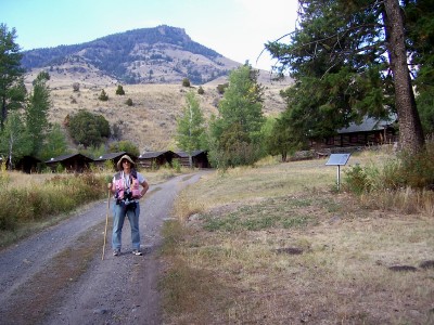
Natasha is relentless in her quest for geocaches. Here, she gives it her all in the Black Hills. Mt. Rushmore is in the upper left hand corner.

Our vision for Off The Beaten Path is a family friendly blog that promotes interest in outdoor activities, curiosity about the world around us and lifelong learning. Our vehicle for that is geocaching and related activities, plus all that goes with them.

You would be hard-pressed to find another activity which is more fun, positive, educational and family friendly than geocaching and its siblings. My 85 year old mother and our two year old grandson have both been out with us.  Some of the best times I ever had as a Dad were with my youngest son hunting down geocaches in the wilds of Montana and Wyoming. When I was teaching school, I used it in my math classes to teach all kinds of things.

One thing you can be sure of – the pages of this blog and our other related sites will develop skills and take you places you would have never known about otherwise.  The only adverse effect we’ve encountered is G.A.S. – Geocaching Addiction Syndrome.  Once it gets in your blood, it’s hard to walk away.

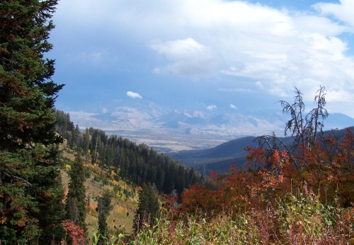
Our adventures have taken us to ghost towns, caves, mountain tops, waterfalls and more out of the way places than we can recall.  It’s been a hoot.  We’ve geocached in 38 states and have a plan in place to finish all 50 by the end of 2012 2013 2014 (or thereabouts).

You never know what you might find here. We love forts, battlefields, ghost towns, one of a kind diners, cheeseburgers, skin-on French fries, anything to do with National Parks and anything else that’s off the beaten path. The tougher, longer, higher, creepier or more calorie-laden it is, the better we like it. Of course, we do normal stuff, too. We’ll mix things up to keep it interesting.

KidsRN at Mt. Rushmore cache site.

Mission accomplished safe and sound. No humans were injured in the production of this blog.

This is an open blog for families, adventurers, explorers, vagabonds and anybody else who might share our passions.  There’s no arm chair traveling here.  We’ve been to all the places we blog about and most of the pictures are ours.

See you in the blogosphere. …Boris and Natasha

Our Top 10 Geocaches – #1

Leave a comment

NOTE TO READERS: In keeping with our philosophy of lifelong learning, we are now on Twitter as @cachemaniacs. If you’re interested, there’s a Twitter follow button over on the sidebar or you can just click the link above.

Well this is it.  After 3,000 geocaches in 40 states over the last six years, we have winnowed it down to the Top 10 – and this is Numero Uno.

Here’s what we have so far.

#10 – Easy to Overlook geocache, Tucson, AZ

#9 – Nuke on a Mountain geocache, Sundance, WY

#8 – The Caves of the Door Bluff Headlands geocache, Door County, WI

#7 – Spooky Tunnel Cache, Kuhntown, PA

#6 – Trolls geocache, Livingston, MT

#5 – Dragoon Springs geocache, Dragoon, AZ

#4 – Civil War Entrenchments geocache, Snake Springs, PA

#3 – Big Springs geocache, Guttenberg, IA

#2 – Rays Hill Tunnel geocache, Breezewood, PA

#1

Trying to nail down the Top 10 is a moving target because as we travel around, we run into a lot of potential Top 10’s. To make the list, there has to be something extraordinary or unique about the geocache under consideration. It might be distance, difficulty, terrain, location, history or just the surroundings. Our #1 cache had them all- and then some. From September 2008 – the OTO Ranch cache near Gardiner, Montana.

In the fall of 2008, we were newly married and newly retired. For our fall road trip, we went back to Yellowstone. A year earlier, I had proposed to Natasha at Old Faithful. So back we went, staying at the Mammoth Hot Springs Lodge near the northern entrance to the park. Just outside the gate is the town of Gardiner, Montana. A search of geocaching(dot)com led us to this cache. It hadn’t been found for almost a year. Usually that’s a red flag, but we went for it. It turned out to be our crown jewel.

OTO Ranch corral

First view of the ranch – the old corral area. If it looks familiar, it should. It’s the background photo for our blog. The restored part is down in the trees on the upper right. The geocache is down by the barn. The ranch sits at about 6,000 feet elevation in the Gallatin National Forest. The round trip hike is around five miles. The mountains in the background are the Absaroka Range, one of the wildest areas in America.

The 3,200 acre OTO ranch was founded in 1898 by Dick and Nora Randall. Dick had been a stagecoach driver in Yellowstone Park for 10 years but realized the potential of outfitting back country trips for wealthy city folk and foreign aristocrats, all of whom were coming to Yellowstone anyway. It soon became a full-fledged “dude” ranch, the first one in Montana. Wealthy city folk began to send their children to work on the ranch for the summer. It wasn’t long before the Randalls had more business than they could accommodate and they began expanding.

The construction was solid and rustic. From 1912 to 1934, guests including Teddy Roosevelt enjoyed hiking, hunting, fishing, horseback riding, wrangling, great food and cowboy music in the beauty of the surrounding Absaroka Range. The Randalls retired in 1934. The operation was taken over by a former client who had no idea how to run a ranch. That, combined with the Great Depression and gathering war clouds, forced it to close in 1939, never to re-open.

The OTO Ranch lodge

The main lodge building. Built in 1921 and abandoned for 50 years, it is as sturdy as ever.

The ranch lay in disrepair for over 50 years. The Forest Service bought the land in 1991 and volunteers began restoring it, an effort which continues to this day. It was entered into the National Register of Historic Places in 2004.

The entire ranch is open to all who make their way there. No cars – walk, horseback, mountain bikes only. There is some serious exploring to be done once you get here. We could have spent all day poking around but we started late and had to get back. Still, we spent over an hour looking around. We found, among other things, a concrete bunker with heavy wooden blast doors built into a hillside near the lodge. We figured it was a bear-proof ice house for food storage in the days before refrigerators.

If you do go exploring, keep in mind that this is real back country. There are bears, mountain lions, wolves, coyotes and big rattlesnakes. If you are tromping through the tall grass (and you’ll have to if you want the cache) make sure you have your stick to check the area around you. If you stay overnight or just go have lunch there, be Bear Aware.

Natasha at OTO Ranch

The always lovely Natasha exploring the ranch.

This was the ultimate geocache. Grizzly bear and rattlesnake warning signs at the trailhead, a moderate hike at high altitude, a killer climb for the first half mile, picture post card mountain scenery, a unique history, lots of buildings to explore and a geocache waiting patiently to be found. So even though we found it over five years ago, it remains our #1.

The GPS coordinates for the center of the ranch are N45.147426, W110.784125. You can click on the coordinates for a Google map. BTW, the cache is still there and still active. It’s had less than 30 visits since we logged it.

Cheers …. Boris and Natasha

The Wild Turkey Geocache

Leave a comment

NOTE TO READERS: In keeping with our philosophy of lifelong learning, we are now on Twitter as @cachemaniacs. If you’re interested, there’s a Twitter follow button over on the sidebar or you can just click the link above.

Hi again,

It’s winter. Even by Minnesota standards, it’s a brutal one. However, we’re in Tucson for four months. One of our favorite places to explore is the Santa Rita Mountains about 40 miles south of the city. Knifing into those mountains is Madera Canyon in the Coronado National Forest. Going from 2,000 feet at the bottom to 9,000 feet on top of Mt. Wrightson, it goes through nine different climactic zones – the equivalent of driving from Arizona to Canada. There are lots of geocaches but few gimmees. Most involve some hiking in steep terrain and many involve some rock climbing. This was one of them.

Natasha at the Wild Turkey geocache.

The lovely Natasha near Ground Zero of the Wild Turkey geocache. The container is a mini-bottle of Wild Turkey bourbon minus the bourbon. Just the log. It’s located in the rocks you can see in the picture and was a tricky hide. It was a challenging two mile hike up the Bog Springs Trail but the scenery was worth it. As you can see, we’ve got our back country gear with us and navigated with our Garmin Dakota 20’s. No cell phone coverage up here. Along the way, we got another geocache and a letterbox. Today, we cruised successfully off the beaten path.

Cheers …. Boris and Natasha

Random Shots – Fall colors in the Teton Pass

2 Comments

NOTE TO READERS: In keeping with our philosophy of lifelong learning, we are now on Twitter as @cachemaniacs. If you’re interested, there’s a Twitter follow button over on the sidebar or you can just click the link above. You can also E-mail us.

Hi again,

One of the great things about geocaching and its kin is that it gets you out into places that you would never go to otherwise. We often come across great scenery in our travels. Particularly out west, there’s a Kodak moment around every bend. Every once in a while though, we happen upon a vista which is there and gone in a moment. Clouds, sky, animals, fall colors, mountains, mist, shadows, snow and sunlight often combine to offer a breathtaking view which is gone in a matter of seconds. Our camera has caught a number of them. This is one of our favorites.

Teton Pass, WY in the fall.

This is the Teton Pass overlooking Jackson Hole, WY in mid-September. Altitude 8,631 feet. We were up here making our way along the spine of the ridge and looking for geocaches (of course). For the most part, it was a dreary day, cold and windy. As we returned to the trail head, the clouds parted and out came the sun. The fall colors exploded and the far mountains came into view. We have gone to places a number of times to catch the leaves at their peak and always seem to be a bit early or too late. On this day, we blundered right into the height of the fall colors. Ten minutes later, we were chased down the mountain by snow flurries and an abundance of caution. The restrictive photo size in the blog doesn’t do justice to the view. Click this link for a full sized version.

Just off to the left of the photo is Highway 22. Called the Teton Pass Highway, it runs from Jackson Hole to Victor, ID through the Caribou-Targhee National Forest. The road is steep and winding. Unlike most American mountain ranges, the Tetons do not have foothills or some sort of transition region. They jut straight up from the flat lands of the Snake River Valley.

Every July, Hungry Jack’s General Store in Wilson, WY sponsors the Teton Pass Hill Climb from the store to the pass. Each rider throws in 20 bucks and winner takes all. Although only 5 1/2 miles long, it gains a half mile in elevation with an average grade of 6.7% and a max of 14%. We’ll stick to Rails-to-Trails.

The photo was taken near coordinates N43.4973° W110.956°. Click on the coordinates for an interactive Google Map.

Cheers …. Boris and Natasha

Random Shots – Parker Homestead, Three Forks, Montana

Leave a comment

This is one of our favorite places and one of my favorite photos. Sitting in the middle of the Jefferson River Valley, it is literally in the middle of nowhere.

The Parker homestead, Three Forks, MT

This is the “back yard” of the old Parker homestead near Three Forks, Montana. First occupied in 1901, hardy settlers lived and farmed here until 1953, living in the log and sod hut which is just off the picture. The jack-leg fence, the old farm implements and the mountains in the distance give this an authentic “off-the-beaten-path-wild-west” look. You can see a branch of Jefferson River in the middle of the photo just above the fence. This year round water source made homesteading here possible.

I took this picture with my old Sony DSC-170, then used Picasa to sharpen the image a bit and boost the colors. This homestead used to be a 1.7 acre Montana State Park but didn’t survive the budget cuts of the recession. Its current condition and status are unknown. That’s a real shame. The Montana plains were once covered with thousands of these. Now, it’s one of the last of its kind.

If you’re interested, the GPS coordinates are N45.845741, W111.676770. Click on the coordinates to bring up a Google map in a separate window.

Cheers … Boris and Natasha

Older Entries